
Blogs

"TAKEN" DYNAMICS TO THE SPATIAL DOMAIN


The foundation for time series analysis methods to detect chaos is the notion that phase spaces and dynamics of a nonlinear dynamical system (NDS) can be reconstructed from a single variable, based on Takens embedding theorem (Takens, 1981). Many years ago (Phillips, 1993) I showed that temporal-domain chaos in the presence of anything other than perfect spatial isotropy (and when does that ever happen in the real world?) leads to spatial-domain chaos. This implies an analogous principle in the spatial domain.

Assume an Earth surface system (ESS) characterized by n variables or components xi, i = 1, 2, . . , n, which vary as functions of each other:

ESS = f(x1, x2, , , , xn)

If spatial variation is directional along a gradient y (of e.g., elevation, moisture, insolation) then

dxi/dy = f(x1, x2, , , , xn)

dx2/dy = f(x1, x2, , , , xn)

.                 .                   .

.                 .                   .

.                 .                   .

dxn/dy = f(x1, x2, , , , xn)

The system can be converted to one highly nonlinear equation by successive differentiation of any xi:

dxi/dy = f(x1’, x2”, , , xnn-1).

Thus, by logic directly analogous to Takens, the spatial series of any realization of the ESS (any component xi) represents the dynamics of the entire dynamical system.

At least, I think so. Comments welcome.

-----------------------------------------

Phillips, J.D.  1993. Spatial-domain chaos in landscapes. Geographical Analysis 25: 101-117.

Takens, F. 1981. Detecting strange attractors in turbulence. Lecture Notes in Mathematics 898, Berlin:Springer-Verlag

Tags:

THE SEMANTICS OF RESILIENCE


Resistance of environmental systems is their capacity to withstand or absorb force or disturbance with minimal change. In many cases we can measure it based on, e.g., strength or absorptive capacity. Resilience is the ability of a system to recover after a disturbance or applied force to (or toward) its pre-disturbance condition—in many cases a function of dynamical stability. In my classes I illustrate the difference by comparing a steel bar and a rubber band. The steel bar has high resistance and low resilience—you have to apply a great deal of force to bend it, but once bent it stays bent. A rubber band has low resistance and high resilience—it is easily broken, but after any application of force short of the breaking point, it snaps back to its original state.

These definitions are broadly consistent in use in Earth sciences, systems theory, and engineering. Unfortunately (at least for interdisciplinary communication), the term is used differently in ecology. Ecologists often use resilience in a way that overlaps with resistance as defined above, defining it as the amount of disturbance that an ecosystem could withstand without changing self-organized processes and structures (defined as alternative stable states). This follows C.H. Holling, who in 1973 popularized ecological resilience (though apparently Elton used the term in ecology in 1958), and termed resilience as I defined it above “engineering resilience”. It didn’t help that Holling defined stability as something separate from resilience, when by some definitions dynamical stability is an indicator of resilience.

It gets even more confusing when you consider that a few ecologists use something like my definition of resilience above, and more confusing yet when you account for the varied way the term is used in the literature of, e.g., environmental management and policy, natural hazards, political ecology, sustainability studies, etc.  In fact the term seems to generate a lot of debate in those fields, though more about implications and interpretations of resilience than its definition.

My introduction to resilience concepts was via geosciences and systems theory. Thus it came as a surprise to me when some geomorphology colleagues reported that, when using the term resilience as dynamical stability, they ran afoul of ecologists in the audience, who argued that they were using the term incorrectly. They weren’t, of course—they just weren’t using it the same way that ecologists often do.

There is unlikely to be any agreement across the sciences on a single, unified definition. Thus, the best we can do is define explicitly what we mean when we use the term.


THE RABBIT HOLE


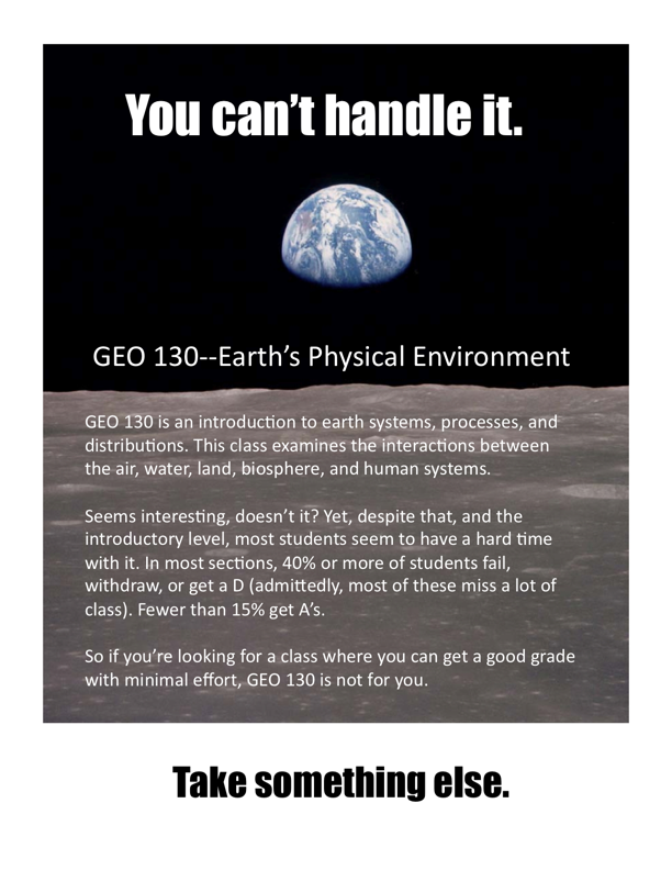
I get frustrated sometimes with the way university administrators are fixated on marketing and branding, and on “student success” implicitly defined as processing as many passing grades as possible (not just at UK; the phenomenon is a pandemic).  Sometimes to relieve my frustrations I make things such as the flier below to amuse myself.


We’re supposed to advertise our courses to make them attractive to students, and to keep them entertained once they are in the class. If they don’t show up, it is the professor’s fault for not being entertaining enough.

I sent the flier to some colleagues in the department, none of whom recommend actually using it (I think I can safely assume that few, if any, potential GEO 130 students will read this blog). However, it has stimulated some interesting discussions.

One of my colleagues who teaches the same course generally has the same philosophy as me, with one exception—he takes attendance and has strict standards. Attendance and grades are better in his sections than in mine, and good on him for that. However, I have always thought that part of the university educational experience involves learning the values of reliability, time management, and taking responsibility for what you do (or don’t do). These students are, after all, legal adults. Thus, while the poor performers who didn’t have “successful outcomes” didn’t learn any physical geography and Earth system science to speak of, I like to think they learned a key lesson about the importance of showing up (all those who failed and the vast majority of those who withdrew or made D’s in my class in the last 3 years had zeros on one or more homeworks or exercises that they failed to turn in or show up for).

Others are adapting to the limited attention span of those for whom watching an entire music video represents a major time commitment.  How can those folks be expected to sit through a 50 or 75-minute lecture or discussion? I genuinely applaud those who are so adapting and reaching some of these students on their own terms.

But shouldn’t our students also be trained, in at least some of their courses, to pay attention and concentrate on things that may not always be entertaining? Won’t they have to do that eventually in the examination or emergency room, in the courtroom or the boardroom, or on the other side of the classroom? Won’t they need to focus for extended periods of time at or in their research sites, job sites, construction sites, labs, battlefields, control towers, and cockpits? Won’t they have to sit through sales meetings, public hearings, briefings, press conferences, and the like?

Others have written much more eloquently on trends in higher education, including the commodification of college education and the pervasive student-as-customer model that’s been growing stronger at least since university administrators jumped on the George Deming bandwagon in the late 1980s and various other retail-education bandwagons since then. Those who think as I do have lost this war for the soul of the university long ago, but I’d sure like to think there is still a place for the vanquished old-school types in Higher Education, Inc.

Getting back to GEO 130, and the fact that this course, like physics, chemistry, math, and many other science/math classes, has higher rates of failure & withdrawal and lower grade point averages than non-STEM1 courses another of my colleagues had this to say:

“I am for a pluralistic approach, let there be multiple styles and content deliveries for 130 . . . that is a strength.  Humans like human ideas, first and foremost, that's how we've become who we are as a culturally-mediated species. I think it will always be a hard sell to get most undergrad students to transcend their/our (necessary, complex, and fascinating) anthropocentrism to think only about Milankovitch cycles, global atmospheric circulation, and tidal bores (no pun intended). We have to keep these subjects on the table even if kinda unfun, lest the whole world go down the rabbit hole of all topics must be fun, familiar, and valuable insofar as they can be parsed down to a twittered opinion.”

Well said—I’m just tryin’ to stay out of the rabbit hole.


1For those who are, perhaps blessedly, not up on the latest edu-speak, STEM stands for Science, Technology, Engineering, and Mathematics. 

RETURN OF THE JEDI

A couple of people (that is, about 50% of the blog’s readership) have asked about the “Jedi” reference in the Jedi Geoscience label. It comes from a PhD student about 10 years ago. After I answered his methodological question about his fieldwork, he good-naturedly suggested that my advice was about as helpful as if I had told him, like the Jedi Knights in the Star Wars movies, to “use the force.” After this story made the rounds, some of the grad students at Kentucky at the time referred to me as the “Jedi Geomorphologist.”

And now you know.


Jedi Geomorphologist using the force.

Tags:

CHANGING LANES

Some form of the diagram below is often used as a pedagogical tool, and to represent a theoretical framework, in fluvial geomorphology, hydrology, and river science. It is called a Lane Diagram, and originated in a publication by E.W. Lane in 1955:

The diagram shows that stream degradation (net erosion and incision) and aggradation (net deposition) responds to changes in the relationship between sediment supply (amount of sediment, Qs, and typical sediment size, D50) and sediment transport capacity (a function of discharge or flow, Qw, and slope, S). The diagram is a very helpful metaphor in understanding the sediment supply vs. transport capacity relationship, and its effects on channel aggradation or degradation.

Unfortunately, the Lane relationship has often been misinterpreted as suggesting that streams somehow adjust Qs, Qw, D50, and S (particularly S) to keep the balance precisely in the middle. A more accurate reading is that if the system is precisely balanced (in steady-state), the slightest change in any factor will tip the scales one way or another. Also, if the scale is way overbalanced on the aggradation or degradation side, it may take a lot of change to level it out or tip it back the other way. Note that many rivers are undergoing net aggradation or degradation, while steady-state is relatively rare, except in a very approximate sense.

I like this version of the diagram (I got it here: http://www.fgmorph.com/fg_2_9.php) because it correctly shows the Lane equation as in the original version, with the proportionality symbol, meaning “proportional to.” This is too often incorrectly rendered with an "approxinately equal" sign, or a ~, which can be interpreted the same. Basically, the Lane relationship means that a change in sediment size, sediment quantity, discharge, or slope will result in a change in at least one of the other variables, and that aggradation and degradation depend on the proportionality of sediment supply and transport capacity.

In retrospect, I wonder if use of the scale/balance visual metaphor has contributed to the misunderstanding that the relationship implies that balance between sediment supply and transport capacity will be maintained. 

DYNAMIC EQUILIBRIUM (?) IN RIVERS

Nicholas Pinter, a Southern Illinois University geomorphologist, gave a nice talk yesterday on rivers and flooding in the 21st century as part of UK’s Water Week. Pinter’s talk got me to thinking about the concept of “equilibrium” in environmental systems and what it means to both geoscientists and laypersons. Pinter correctly noted that rivers tend toward dynamic equilibrium, and more specifically, dynamic metastable equilibrium. This means three things: First, the system (river) is more or less constantly changing (the dynamic part). Second, equilibrium is of the type envisioned in mathematics and systems theory—that is, a state or condition the system settles into after a change or perturbation, with no further connotation other than that the response to the change has run its course (I’ve called this “relaxation time equilibrium” in my work). Third, “metastable” means that these equilibrium states are not necessarily stable and self-maintaining, and may be sensitive to future disturbances—even relatively small ones. Pinter’s message is that dynamic equilibrium in rivers means that rivers are constantly changing.

Lockyer Creek, Queensland, Australia; still adjusting in 2013 to effects of a flood in 2011.


This is in ironic contrast to the usual layperson’s understanding of equilibrium, which typically equates it with some sort of normative state of balance. This implies that there is a single normal or natural condition, and that following a change the river should return to this condition. This can happen, but often does not!

Dynamic metastable equilibrium is also, confusingly, inconsistent with the concept of dynamic equilibrium introduced into geomorphology in the 1950s and persisting to this day. This “dynamic equilibrium” is actually (as I am hardly the first or only geomorphologist to point out) a steady-state equilibrium (SSE). SSE implies that inputs and outputs are approximately balanced over time, so that even as the system is modified by, e.g., erosion and deposition, its general state doesn’t change. Thus, for instance, SSE implies that the amount of sediment entering a river is roughly balanced by the river’s sediment transport capacity, or that the rate of uplift of a mountain range is equal to the rate of denudation. SSE indeed occurs in real Earth surface systems—and is a very useful concept as a reference condition or a simplifying assumption for models—but is rare, transient, and approximate with respect to what is actually happening in rivers or other systems.

Because of the confusion of scientists and laypersons alike about what equilibrium actually means, I have pretty much stopped using the term except when it is carefully qualified. However, the word and the concepts are irreversibly entrenched, and if we are going to continue to use them, Pinter’s approach—that dynamic equilibrium means dynamic metastable equilibrium, and that rivers are constantly changing—is the way to go.

Some of my more technical and extensive thoughts, rantings, and analyses on these points are given here:

Phillips, J.D., 2014. Thresholds, mode-switching and emergent equilibrium in geomorphic systems. Earth Surface Processes and Landforms 39: 71-79.

Phillips, J.D. 2013.  Geomorphic responses to changes in instream flows: the flow-channel fitness model. River Research and Applications 29: 1175-1194.

Phillips, J.D.  2011.  Emergence and pseudo-equilibrium in geomorphology. Geomorphology 132: 319-326.

Phillips, J.D.  2010.  The convenient fiction of steady-state soil thickness. Geoderma 156: 389-398.

Phillips, J.D. 2010. The job of the river. Earth Surface Processes and Landforms 35: 305-313.


THE TRIAD

Explaining and understanding Earth surface systems almost always requires some triangulation between three different sets of factors. The first, examples of which are shown on the lower left corner of the triangle below, are general principles and relationships that apply everywhere and always. Second, on the upper point, are environmental factors--characteristics of locations and regions such as climate, geology, etc. On the lower right of the triangle is the third set of factors, related to past events and time available for the system to develop.

This can be generalized as laws, place, and history, as shown below. 

The laws-place-history triad has, at least implicitly, long been used for explanation by many Earth and environmental scientists. Inspired by the "epidemiological triangle" used by medical geographers, I began depicting the framework in triangular form as a pedagogic device for my classes. I recently used it in a research presentation, and several in the audience commented that they found it useful. As I doubt whether I will ever have time to write it up in any more formal setting, I decided to post it here. 

The triangle can be used in other contexts, as well. For example, plant geographers and ecologists might explain vegetation communities on the basis of general biotic laws, the environmental setting, and past land uses, disturbances, biological legacies, etc:

Finally, here is an example I use in my introductory physical geography class. Mammoth Cave, the world's longest, is in south central Kentucky. What explains the presence of such an extraordinary feature? First are the general principles of karst geomorphology and cave location that would apply in any karst landscape (lower left). Second are a particular set of geographic characteristics, such as thick, pure limestones overlain by a protective sandstone caprock, that allow large cave passages to develop. Finally, the incision history of the Green River--where all the water creating and moving through Mammoth Cave eventually drains--has allowed the development of multiple, successive levels of the cave.


BADASS GEOMORPHOLOGY

Yesterday I was honored to give the annual Linton Award lecture to the British Society for Geomorphology at the University of Manchester. Many thanks to the BSG for making my attendance possible, and to the U. Manchester geography department for putting on a good meeting. This is the abstract of my talk, entitled Badass Geomorphology:

The archetypical badass is individualistic, non-conformist, and able to produce disproportionate results. The badass concept is applied here to geomorphology. The individualistic concept of landscape evolution (ICLE) is introduced, based on three propositions: excess evolution space, capacity of all landforms to change, and variable selection pressure from environmental factors within and encompassing landscapes. ICLE indicates that geomorphic systems are idiosyncratic to some extent, and that even where two systems are similar, this is a happenstance of similar environmental selection, not an attractor state. As geomorphic systems are all individualistic, those that are also non-conformist with respect to conventional wisdoms and have amplifier effects are considered badass. Development of meander bends on a section of the Kentucky River illustrates these ideas. The divergence of karst and fluvial forms on the inner and outer bends represents unstable amplifying effects. The divergence is also individualistic, as it can be explained only by combining general laws governing surface and subsurface flow partitioning with a specific geographical and environmental setting and the history of Quaternary downcutting of the Kentucky River. Landscape evolution there does not conform to any conventional theories or conceptual frameworks of geomorphology. The badass traits of many geomorphic systems have implications for ontology, epistemology, and aesthetics. Badass geomorphology and the ICLE reflect ontology (and an associated epistemology) based on landforms as the outcome of the interplay of general laws, place-specific controls, and history. Badass geomorphology also implies a research style receptive to contraventional wisdoms. Aesthetically, amplifier effects and individualism guarantee an essentially infinite variety of landforms and landscapes that geoscientists can appreciate both artistically and scientifically. Non-conformity makes the interpretation and understanding of this variety more challenging—and while that increases the degree of difficulty, it also makes for more interesting and compelling professional challenges. 

RIVER RESTORATION & REHABILITATION


Yesterday I heard a very interesting river restoration workshop at the British Society for Geomorphology meeting. What I’m about to discuss was not the focus of the workshop, but it was triggered by thinking about geomorphology, hydrology, and river science in stream rehabilitation and restoration, which is a big business now.

The stream restoration problem is often portrayed as something like this:


That is, the stream is currently in some kind of degraded, suboptimal, unwanted state. The goal is to restore it to a “natural” or some more desired condition, often conceived as whatever the stream was like before the degradation commenced. There are a number of problems with this, one being that in many cases the pre-existing state is not known. Even if it is, since rivers—like other landforms and ecosystems—are dynamic and changeable, there is no particular scientific reason to believe that, in the absence of human-driven changes, the river would still be now as it was decades ago.

Indeed, there is no single natural, normal state for a river to be in. Rather, there are a range of possibilities, constrained by the laws that govern fluvial geomorphology and contingent on local environmental conditions, past events, and the trajectory of fluvial change. There is also, of course, more than one way for a stream to be degraded. So I see it more like this:


The “natural” circle represents the often large but always finite range of possible natural (i.e., with minimal human influence) states, and the “degraded” one the possible degraded states. There is some overlap because occasionally degradation can occur without human meddling.

Now let’s figure in a number of possibilities for restored rivers, which sometimes mimic natural states, and which occasionally go wrong and contribute to degradation. Using “engineered” as shorthand for river modifications whose primary goal is something other than restoration (navigation, water supply, erosion control, drainage, etc.), the Venn diagram looks like this:

In restoration/rehabilitation, we are concerned with a specific, existing degraded condition. There must be some sort of target or goal for restoration, however, be it a pre-existing condition, an undisturbed reference stream, or meant to achieve some specific environmental goal or ecosystem service.

If we do it this way, however, we need to realize that the target is a choice from among multiple possibilities, not a recovery to a single “right” condition. A number of conceptual frameworks for river R & R recognize the natural dynamism of fluvial systems, the multiple possible states and trajectories, and that there is no single natural state. This approach, symbolized below, is in many cases more practical, less expensive, and more “natural” that attempting to restore a specific state.

Rather than (re)constructing a specific stream condition, the idea is to remove modifications and/or restore process regimes that will allow movement away from the degraded state—not to some specific target, but to somewhere within the natural circle. These ideas, by the way, are applicable not just to rivers, but to ecosystem restoration and environmental rehabilitation more generally.

TUITION AND TEACHING


I am off to a meeting today, where I will meet with an old professional friend who teaches at an Ivy League university. Also today, the first bill arrived for my daughter’s tuition at a prestigious Midwestern private university. My colleague has lots of time for travel, as he teaches, over the course of a year, about half of what those of us in state universities teach. But what struck me today was not sour grapes about teaching loads (I actually think teaching is important, and usually enjoy it—it’s the administrative BS of the state university that drives me up the wall). It was wondering how much of the outrageous sum I’m about to shell out is actually funding my daughter’s education, vs. paying professors at that university not to teach very much.

One thing I can say about my university—and many other state universities—is that while we do not have as many big-name academic superstars as some of the prestigious private schools, we do have some. And if your kid comes here, she or he has a reasonable shot of actually encountering them in the classroom. I wonder to what extent that is true in the Ivies and their peer institutions. I hope, for the sake of my daughter and my own consumer self-esteem, that my cynicism is misplaced.