
earth and environmental sciences

Δ DELTAS


Several studies have noted the temporal coincidence between shoreline erosion around some major deltas (e.g., Nile, Mississippi, Ebro), and the reduction of stream sediment loads due to reforestation, soil conservation practices, and trapping of river sediment behind dams. There are, of course, excellent reasons to suspect a causal link, but the link itself has not, in my view, been fully established.

Rast-Holbrook Seminar

4:00-4:25 Dr. Adam Milewski, Assistant Professor of Geology, University of Georgia, "The Past, Present, and Future of Water Resources in the Middle East and North Africa Region"
4:30-4:55 Dr. Neda Zawahri, Associate Professor of Political Science, Cleveland State University, "Management of Transboundary Rivers in the Middle East"
5:00-5:25 Discussion moderated by Dr. Alan Fryar

Date:
Location:
303 Sloane

THE CYCLE OF EROSION


Out on the trails of Shaker Village at Pleasant Hill, Kentucky, this morning, I got to thinking about William Morris Davis’ “cycle of erosion” conceptual model (also called the geographical or geomorphological cycle). The drive-by, oversimplified version is that landscape evolution starts with uplift of a more-or-less planar, low relief surface. Weathering and erosion goes to work, and results in an initial stage of increasing relief as streams carve valleys, and slope processes operate on the slopes thereby created. Eventually, however, as the streams begin to approach base level, a new stage of decreasing relief begins as hilltops and drainage divides are lowered and valleys infilled. This continues until the entire landscape is about as close to baselevel as the geophysics of mass transport will allow, creating a low-relief, almost-planar surface called a peneplain. At some point a new episode of uplift occurs and the cycle begins anew.

I was thinking of this because many landscapes in the world, like the one I was viewing this morning, do give the impression of a dissected plateau or a low-relief surface into which denudational processes have cut.

HYDROPEDOLOGY: FLUX-STRUCTURE INTERACTIONS

Subfields such as biogeomorphology, ecohydrology, geoecology, soil geomorphology are areas of overlap between disciplines and subdisciplines. They are governed by the paradigms of the overlapping fields, and fit more or less comfortably within, and at the boundaries of, those fields. They do not have an independent paradigm or conceptual framework (which in no way reduces their importance or vitality).

Landscape ecology, by contrast, has developed its own paradigm—pattern, process, scale—that is independent from mainstream ecology, biogeography, and geospatial analysis.

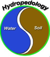
Does, or can, hydropedology have such an independent paradigm? Is its development best served by, say, the ecohydrology or soil geomorphology model as an overlap field dominated by existing paradigms of pedology and hydrology? Or is a landscape ecology, separate paradigm direction more appropriate?

NATURAL SELECTION


Natural selection is most familiar with respect to Darwinian evolution. However, though some biologists will argue that selection acts only on genes, this is a very narrow and restricted view. Selection operates on a variety of environmental phenomena, and at a variety of scales. In hydrology and geomorphology, the principle of gradient selection dictates that the most efficient flow paths are preferred over less efficient ones, and that these paths tend to be reinforced. That’s why water flows organize themselves into channels (more efficient than diffuse flows), and channels into networks. The principle of resistance selection in geomorphology is simply that more resistant features will persist while less resistant ones will be removed more quickly. Thus geomorphic processes select for certain forms and features and against others. Among others, Gerald Nanson, Rowl Twidale, and Luna Leopold have written on selection in geomorphology, and Henry Lin, among others, in hydrology.


Principle of gradient selection at work--Board Camp Creek, Arkansas

ANASTAMOSING CHANNELS

Recently published in Earth Surface Processes & Landforms: Anastamosing Channels in the Lower Neches River Valley, Texas. The abstract is below: 


Active and semi-active anastomosing Holocene channels upstream of the delta in the lower valley of the meandering Neches River in southeast Texas represent several morphologically distinct and hydrologically independent channel systems. These appear to have a common origin as multi-thread crevasse channels strongly influenced by antecedent morphology. Levee breaching leads to steeper cross-valley flows toward floodplain basins associated with Pleistocene meander scars, creating multi-thread channels that persist due to additional tributary contributions and ground water inputs. Results are consistent with the notion of plural systems where main channels, tributaries, and sub-channels may have different morphologies and hydrogeomorphic functions. The adjacent Trinity and Sabine Rivers have similar environmental controls, yet the Trinity lacks evidence of extensive anastomosing channels on its floodplain, and those of the Sabine appear to be of different origin. The paper highlights the effects of geographical and historical contingency and hydrological idiosyncrasy.


Subscribe to earth and environmental sciences